Our next destination was Big Bend National Park. The only real stop along the way (other than gas) was in Fort Stockton – groceries and then we wound up at the local feed store to pick up permits to camp in a wildlife management area next to Big Bend. Here is where Mike figured out his driver’s license was missing. Luckly, he still had his passport for identification, but the license was nowhere to be found after much searching.
And then we drove on for two more hours, into the middle of nowhere. We lost cell service at least an hour from our destination, but got to see a javalina and some jackrabbits along the road.
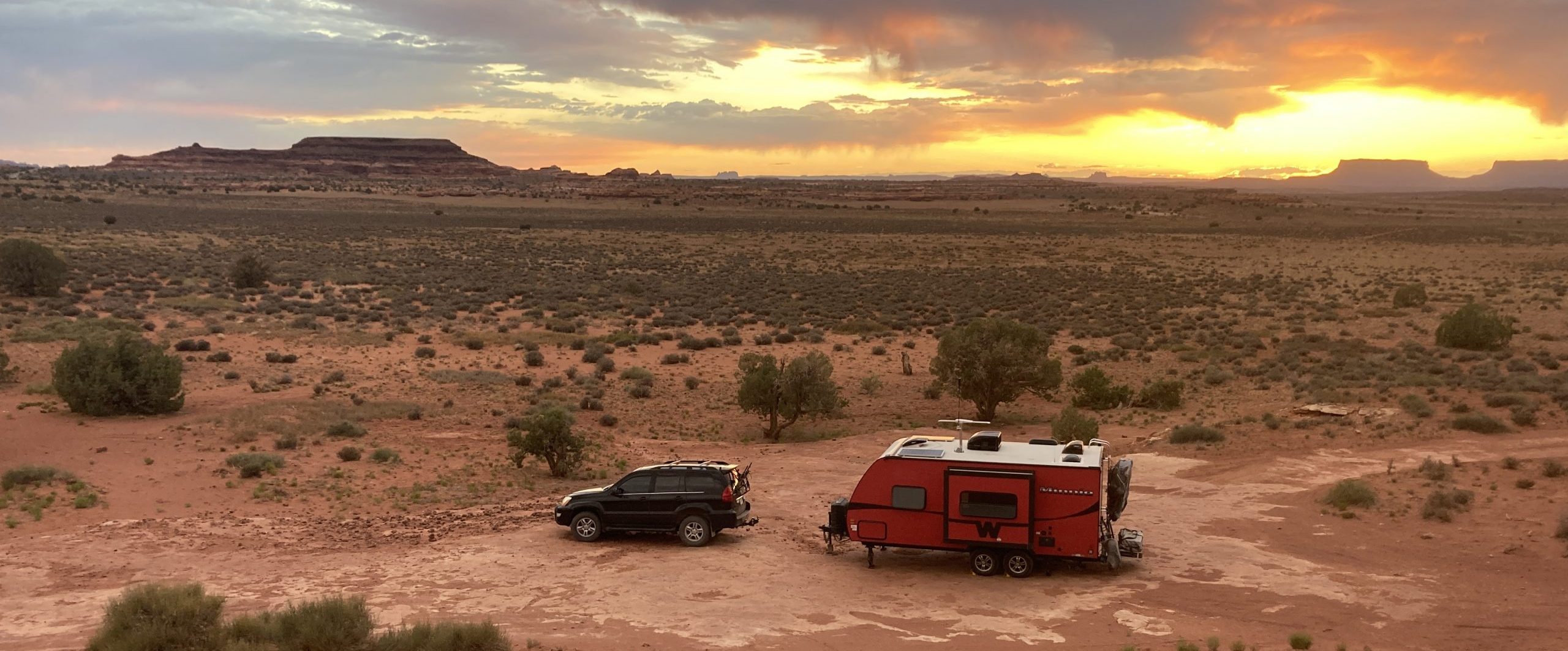
We arrived at Black Gap WMA knowing that there were dispersed sites spread out over 100,000 acres, but we chose to stick close to the entrance so we could get to Big Bend more quickly. There were a few small maintenance and office buildings nearby, but other than that, we pretty much had the area all to ourselves. We were truly in the desert, surrounded by cactuses and rocks, hot sun beating down, and the occasional dust devil popping up nearby. While settling in, Mike remembered that he had given me his driver’s license so I could pick up an order at Home Depot, way back in The Villages. When I couldn’t find it in any of my things, my best guess is that it fell out of my pocket while driving Barry’s Solara convertible, a lovely car that sits low enough to draw many things out of one’s pockets. (When we called Mike’s dad a few days later, the license was indeed found in the car and mailed off to Colorado, our next foreseeable friend stop.)

Big Bend was a ways away, so we made an earlish start the next day. We had three days to explore the area since there was no way that Mike could work anywhere nearby, so we went for the eastern half of the park on the first day.
We headed down a high clearance road to get to the trailhead for Pine Canyon Trail. It had been touted as a highly trafficked trail, but when we got to the parking area for it and saw room for about 6 vehicles total, we decided that Big Bend busy is different from other national park busy. The trail took us from a desert landscape with mountains as a backdrop into the mountains. Cactus and yucca gave way to pine and oak trees and we moved from full sun to mostly shade as we climbed into the canyon. We were a little too late in the season to see any waterfall at the end from snow melt, but the hike was well worth the effort even without it. We met some very nice official volunteers on the trail who gave us some suggestions for what to see in the park and offered assistance when Mike decided not to make the final steep climb to the end of the trail because of some heel issues. Luckily, it seemed to be only a pinched nerve and he was able to recover from it without too much trouble.


Squaw Root, a parasitic plant that grows on oak roots.


The injury, as well as some blisters that I had gotten on the hike made us decide that most of the rest of the day would be exploring by car. The temperature on the hike had been quite nice, but by the time we got back to the car and lower in altitude in the park, we were glad that we had no more long hikes on the day’s agenda.
We drove down to Rio Grande Village to view the river and cool our feet in it a bit.


We then decided to try for one last hike, or part of a hike, that the volunteers had recommended. We headed up Old Ore Road that warned of the need for a high clearance vehicle and 4 wheel-drive. It was a very slow and bumpy ride to the Ernst Tinaja trailhead. The volunteer had told us that this was the one spot in the park where there would still be water, other than the Rio Grande. When she talked about depressions that held water, I had pictured something small, but it was only a short hike up a dry creek bed to the tinaja which was about 15 feet in diameter and was indeed filled with water. I later learned that there is a spring that feeds the tinaja, hence the ever present water.


Driving back to the main road, we were a little surprised to encounter a Mazda 6 making its way in the opposite direction. This road followed an old pack mule trail and traversed ravines, steep hills, and both very rocky and sandy areas. I can’t say that I would want to jeopardize a car on it, but to each their own.
We filled up on gas at one of the visitor centers before heading back to our campsite which was about an hour away. This place is so remote and big that it has three gas stations inside it!
That night, we took in the incredible stars before going to bed and were woken in the middle of the night by a desert rainshower. What more could we want?
Because we both needed a recovery day after our first real hike in quite a while, we decided to explore Black Gap the next day. Our campsite was about 15 miles from the Rio Grande, so we made our way slowly around mountains and through very rough terrain to see what we could see. We found great views, a some more blooming cacti to whet out photographic thirst, a few cows, lots of cow patties, and a couple of old steam engines. The thing we didn’t find was easy access to the river, though we tried a few times. We followed cow paths through enormous stands of carrizo cane, a bamboo-like plant that was all along the river bank where the approach was shallow enough to navigate. Unfortunately, at the spot where we had the nicest access, the water’s edge was covered in algae and was kind of gross. Mike ventured forth though, to briefly cross the river onto the banks on the Mexico side. Don’t worry, he was still carrying his passport.


We saw a few trucks by the side of the road that belonged to employees of the WMA, but the only people we saw were some border patrol agents driving around. We chatted with them for a minute, never needed to show ID, and were on our way.
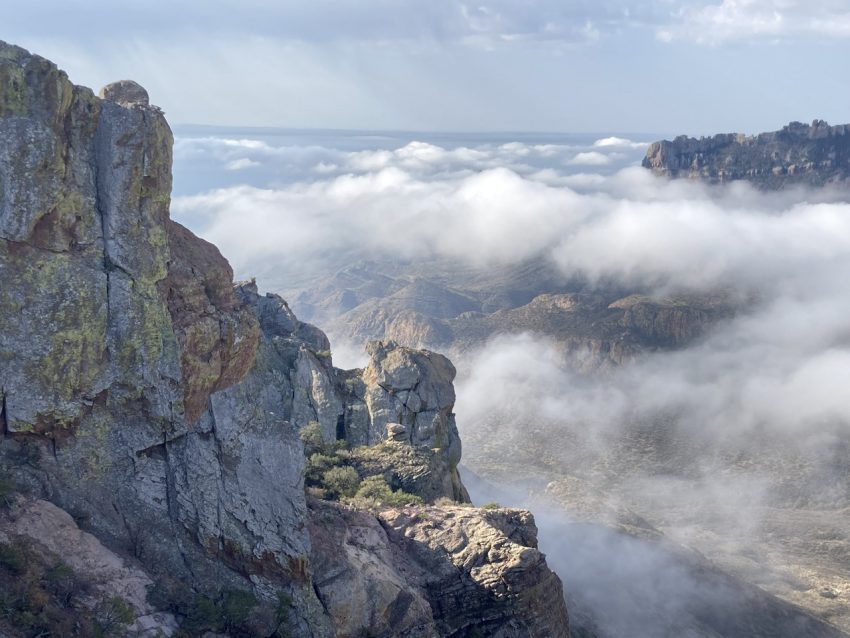
Our last day in the area took us back into Big Bend. We were up early so that we could get a parking spot at a trailhead along Chisos Basin Road, which lead over the mountains and into a basin which hosted a visitor center, a lodge and the start of many trails. When we left Black Gap, the sky was clear, but we soon were driving through thick fog. We had clear driving for the rest of the way until we got onto Chisos Basin Road and started to go over the mountains. The fog (or clouds) were so thick that I thought about turning us around to do something else, but just as I was looking for a spot to turn around, the fog cleared and we soon came to the trailhead.
We took to the trail and watched the fog move around the surrounding mountains. The fog stayed below us, obscuring any views down into Juniper Valley, but it just gave the views a different kind of beauty. We climbed in the shade of the mountain, catching bits of sun here and there, but not getting full sun until we reached the peak. And there, we had vistas.


We continued on to Chisos Basin and did some short hikes to explore the area. Apparently, the basin gets 2-3 times more rain than the surrounding area and this leads to a different kind of biodiversity than in other parts of the park.


We took the rest of the day to drive through the rest of the park on Old Maverick Road (high clearance) and Ross Maxwell Scenic Drive. We stopped often to take pictures of things big and small, admire the incredible vistas, and visited Santa Elena Canyon.


One last stop on our way our of the park: the Dagger Flats Auto Trail. This was another recommendation from a volunteer in the park. We had seen quite a few blooming yucca throughout both Big Bend and Black Gap, but apparently, this was the spot to see a forest of Giant Dagger yuccas. These were twice as tall as the Torrey yucca that we had seen more often in other parts of the park.


